Protect Our Parks
Highlights
2024 Work on the Master Greenspace and Natural Corridors Plan is underway and a draft could be available as early as 2025
Winnipeg City Council signed the Montreal Pledge - July 13, 2023 montreal.ca/en/articles/montreal-pledge-call-cop15-launched-to-worlds-cities-39529
2022 Winnipeg Parks Strategy approved by City Council May 26, 2022
2022 City of Winnipeg approved the creation of the *Master Greenspace and Natural Corridors Plan and Biodiversity Policy for Winnipeg and 1000 additional acres of greenspace*
Transformative amendments were approved for Winnipeg’s two key planning documents Winnipeg 2045 and Complete Communities 2.0 to keep green space intact and to add more . Council gave approval to the amendments on June 24 2021.
2024 Work on the Master Greenspace and Natural Corridors Plan is underway and a draft could be available as early as 2025
Winnipeg City Council signed the Montreal Pledge - July 13, 2023 montreal.ca/en/articles/montreal-pledge-call-cop15-launched-to-worlds-cities-39529
2022 Winnipeg Parks Strategy approved by City Council May 26, 2022
2022 City of Winnipeg approved the creation of the *Master Greenspace and Natural Corridors Plan and Biodiversity Policy for Winnipeg and 1000 additional acres of greenspace*
- City Planning Documents - OurWinnipeg 2045 and Complete Communities 2.0 Third Reading approved by City Council May 26, 2022 including transformative green amendments.
- City Council approved funding in Budget 2022 to create a Master Greenspace and Natural Corridor Plan and Biodiversity Policy for $700,000 ($200,000 for 2022 and $500,000 for 2023). (Dec 15 2021)
- 5. Protect and value ecosystems as essential components to life. Protect and respect the land through the City’s responsibility to ensure that life-sustaining ecosystems continue to provide clean air, clean water, biodiversity, local food systems, natural habitats, ecological
restoration, carbon sequestration, cooling of urban heat island effect, opportunities for Indigenous land based practices, and improved mental and physical health.
Transformative amendments were approved for Winnipeg’s two key planning documents Winnipeg 2045 and Complete Communities 2.0 to keep green space intact and to add more . Council gave approval to the amendments on June 24 2021.
- Create a Master Greenspace and Natural Corridor Plan By-law and Biodiversity Policy
- Consideration of municipal golf courses as major nature preserves and greenspace
- Commitment to acquire an additional 1,000 acres of public park space
Important Policy in City Planning Document - OurWinnipeg 2045
2.19 Leverage Green Infrastructure
Value, protect and integrate green infrastructure solutions within the urban environment, to achieve highest and best use for biodiversity and ecosystem integrity, mitigate servicing capacity constraints, and accommodate only park, recreation, open space, or City operations related uses in City-owned land used as parks or under parks jurisdiction. HW, CB
2.20 Leverage Green Infrastructure
Create a master green space and natural corridor plan by-law that enables conservation, management, restoration, and enhancement of the inherent value and ecological functioning of parks, waterways, natural areas and systems year-round, to support the environment, advance climate change adaptation and mitigation, and increase quantity of such lands by 1,000 acres that can be accessed for recreation, social interaction, active living and connection of people and nature with nature, as population growth occurs. HW, CB, SE
2.21 Leverage Green Infrastructure
Conserve, restore, and enhance the urban forest as a key contributor to air quality, erosion control, carbon sequestration, storm water management, efficient energy resource consumption, shade, improved health and well-being, and mitigation of and adaptation to the urban heat island effect. HW, SE
Link to full wording of Planning Documents Greenspace amendments - June 24, 2021 Council Meeting
- OurWinnipeg 2045 clkapps.winnipeg.ca/DMIS/ViewDoc.asp?DocId=21053&SectionId=609806&InitUrl= (starting on page 3 and ending on page 8)
- Complete Communities 2.0 clkapps.winnipeg.ca/DMIS/ViewDoc.asp?DocId=21053&SectionId=609812&InitUrl= (starting on page 6 and ending on page 16)
OURS-Winnipeg Presentations for Planning Documents OurWinnipeg 2045 and Complete Communities 2.0
1. OURS-Winnipeg ASK'S
2. OURS-Winnipeg Topics
3. Muriel St. John
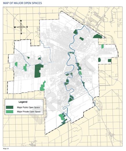
Map credit - City of Winnipeg Complete Communities 2.0 Draft
|
- Map of Major Open Spaces from Planning Documents OurWinnipeg 2045
- Major Open Space chapter of Complete Committees 2.0 Draft, p. 119 - 124
- Greenspace Chapter of 2018 Winnipeg Alternative Budget
Urban Greenspace Provides Multiple Benefits and Must be Protected and Enhanced
Master Plan for Greenspace
A Master Plan for Greenspace is a holistic, multi disciplinary plan that includes all greenspace and bluespace in the city, both public and private. A plan provides a holistic approach and coordination among city departments and partners. Greenspace includes parks, natural areas, urban forest, river corridors, water features where ever they may be located. Plans can extend into surrounding municipalities and rural areas as greenspace and river corridors do not stop at boundaries. A Master Plan contains many components and sub plans from various levels of government Some components are a Biodiversity plan, parks plan, river corridor protection plan, a tree bylaw. It incorporates health, biodiversity, climate adaption, social and accessibility goals.
The WHO defines urban greenspaces as all urban land covered by vegetation of any kind. (Urban green spaces: a brief for action. UN City, Denmark: World Health Organization Regional Office for Europe. 2017)
Currently in Winnipeg , matters pertaining to greenspace are fragmented across multiple departments with different goals, by-laws, budgets, and regulations although their management is left largely to the Parks and Open Spaces Division with a finite budget and scope. The budget allocation for Parks and Open Space Delivery Service have been underfunded for years.
Edmonton has an award winning Master Plan for Greenspace called "Breathe".
Edmonton’s plan incorporates policies from all levels of government, stakeholders, funding, population health, environment, ecology, climate adaption, biodiversity, waste management, risk mitigation, food production, aesthetic value, heritage and more. It contains four pages that list the plans, regulations and standards from Federal, Provincial and Municipal governments that provide guidance for their Greenspace plan. Edmonton employs Ecological Planners.
Winnipeg is in the process of developing a Parks Strategy, a Recreation Strategy, Urban Forest Strategy and tree bylaw. It takes time to build the foundation for a master plan and cities have been working on them for decades. OurWinnipeg 2045 and Complete Communities 2.0 were amended in June 2021 by Council to create a Master Greenspace and Natural Corridor Plan and Biodiversity Policy.
Other cities have Master Plans for Greenspace and component plans to guide decision making.
Edmonton
- “Breathe” has four pages of policies and plans from Federal, Provincial and City levels of governments that guide it, plans have been evolving over 20 years. Pages of stakeholders, funding plan, etc
- Ecology, Wellness and Connection
- Wildlife Passages and Engineering Design Guidelines for river corridors
- Parkland Strategy four functions: Ecology; Sport + Play; Community; and Health + Wellbeing.
- Wild Connected and Diverse Biodiversity Plan
- Toronto Urban Ecosystem
- Resilience Strategy
- Greenest City
- VanPlay
- Nature in the City
- Mapping software to determine where parks most need to be added
- Regional Tree Canopy Cover and Impervious Surfaces
- Accessibility
- Storm water Source Control Design Guidelines 2012 supports wetlands
Special Charter Protection for Parkland
- Parkland (park zoned) has special protection from development in the City of Winnipeg Charter, Clause(1)(d) -
History
Winnipeg has a 100 plus year legacy of visioning and altruistic intentions for its parks, through tough times and good as parks, large and small, were added throughout the city and beyond city limits to provide services and comforts deemed necessary for its growing population.
In recent times parks have been threatened as too costly, too many, better uses can be found . Budget solution to sell and develop on park land.
- 1893 - Winnipeg Public Parks Board first met in 1893 to acquire, improve and maintain public parks. The provision of public parks were to improve housing and sanitation and reduce the threat of infectious disease. Recognized were the economic value of beautification, the need for fair access to recreation and the need to counter the deleterious effects of urbanization on the working classes.
- 1904 -1906 Assinboine Park was designed by Frederick Gage Todd, Canada's first professional landscape architect at a time when the idea of naturalistic open space in Canadian cities was popularized. In Oct 2020 the Government of Canada designated Todd as a person of national historic significance for his contribution to Canadian park planning.
- 1921 -1982 The City-owned golf courses were created between 1921 and 1982 by seven different Mayors with Mayor Stephan Juba creating three. Kildonan GC was created shortly after the first WW. Three of the golf course were created during the Great Depression in the thirties.
- 1961 - Parks became part of the new Metropolitan Corporation of Greater Winnipeg’s legacy.
One of the initial pledges made by Metro was to add 1,000 acres of parkland by acquiring land in and around urban areas. The goal was exceeded.
Parks to emerge from this period include La Barriere, Little Mountain, John Blumberg and its golf course, Maple Grove, Bonnycastle, and King’s Park. - 2006 - City was forced to back down on proposal to put Condos in Assinboine Park
- 2011 - 2013 Attempts made to sell or develop seven of the city-owned golf courses. Public push back caused the plan to be halted.
- 2013 - John Blumberg Golf Course, part of the Headingly recreation complex declared surplus.
- 2020 - Repurposing 30% of Golf Lands Strategy and Transformative Fund (dispense revenue from city owned real estate declared surplus)
- 2020 City Planning document's 25-year vision enables development on Major Open Space (Winnipeg's largest parks which make up half of all city-owned greenspace).
- 2021 - Kildonan Golf Course celebrates 100th anniversary.
- 2021 Planning documents amendment to include amendments to preserve and expand greenspace with creation of Master Greenspace and Natural Corridors Plan By-law and Biodiversity Policy
- 2022 John Blumberg Golf Course removed from surplus properties list, City Council reversed 2013 decision.
- 2022 City began work on Master Greenspace and Natural Corridors Plan and Biodiversity Policy. City approved $700,000 budget to create the plan.
- 2023 Repurposing Golf Courses Strategy documents re written to remove development option with passive recreation.
- 2024 City of Winnipeg became a signatory to the Montreal Pledge - Cities United in Action for Biodiversity
